
To view more of @outdoorfergie’s images please visit scottishhorizons.co.uk
Loch Katrine and Loch Arklet, which both sit in the heart of Loch Lomond and the Trossachs National Park, have been the source of Glasgow’s drinking water since 1914.
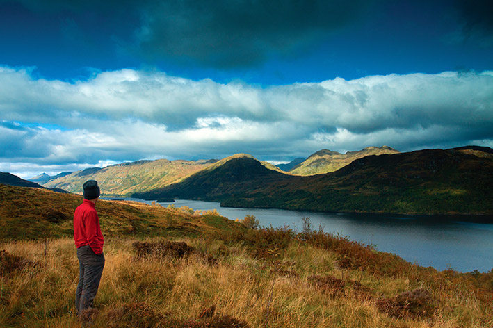
They are separated by a wild expanse of moorland where tangible evidence of this engineering marvel exists and a fantastic walk links both bodies of water.
The route begins from Stronachalacher (which translates from Gaelic as ‘The Stonemason’s Point), on the banks of Loch Katrine (itself possibly meaning ‘The Dusky Loch’), only a couple of miles away from Glengyle.
Here, in 1671, one Rob Roy MacGregor was born. He was involved in the Jacobite uprising of 1688 and became a folk hero, chiefly because of his feud with James Graham, 1st Duke of Montrose. Rob Roy died at Balquhidder in 1734.
In 1817, 7 years after writing his epic poem, ‘Lady of the Lake’, Sir Walter Scott published ‘Rob Roy’, a somewhat exaggerated account of Rob Roy MacGregor that romanticised his life. Just like ‘Lady of the Lake’, Scott’s book contributed greatly to the popularity of The Trossachs.
Leaving Stronachlachar, a private road runs above the loch, soon crossing an aqueduct. This flows from Loch Arklet and was opened in 1914 to provide extra water for Loch Katrine, which had supplied Glasgow’s water since 1859.
The 34-mile Loch Katrine/Glasgow aqueduct was an incredible feat of engineering, as it required no pumps, the water’s flow wholly driven by gravity.

The road provides easy walking for a further 3km where it reaches a waymarked footpath on the right. Yet it’s worthwhile keeping on for another 100 metres to the striking Royal Cottage. This was built as accommodation for Queen Victoria when opening the water scheme in 1859.
However a local story states that a 21-gun salute smashed all the windows and therefore she couldn’t stay overnight.
Walk back to the waymarked path which climbs away from Loch Katrine. Continue over moorland, passing a ventilation shaft, a legacy of the aqueduct’s construction. Turn right at the next shaft, following a narrow path to the walks highest point.
This spot has a wilder air and presents a superb view to Ben Lui’s magnificent profile, while to the southwest rises Ben Lomond.
Back at the main path continue as it traverses beneath Tom Ard, eventually descending to a forestry track. Turn right and follow this to a path on the right, just before the B829.
A wonderful section of the walk continues across moorland, following the route of the Statute Labour Road that once ran between Aberfoyle and Inversnaid.

The paths and roads alongside Loch Arklet have been used for centuries. The old Military Road (which the B829 runs along today) was built around 300 years ago to serve the Inversnaid Garrison. Soldiers were stationed here to guard the road and keep control of local rebels and cattle thieves, who would have had superb knowledge of the local topography for their illicit deeds.
In due course a stunning view across Loch Arklet and the Arrochar Alps grabs your attention and once at the B829, an easy walk returns to Stronachlachar.
